 Facebook
 X
XDecoding the Waves: Explore ShipXplorer's Latest Tool for Mariners!
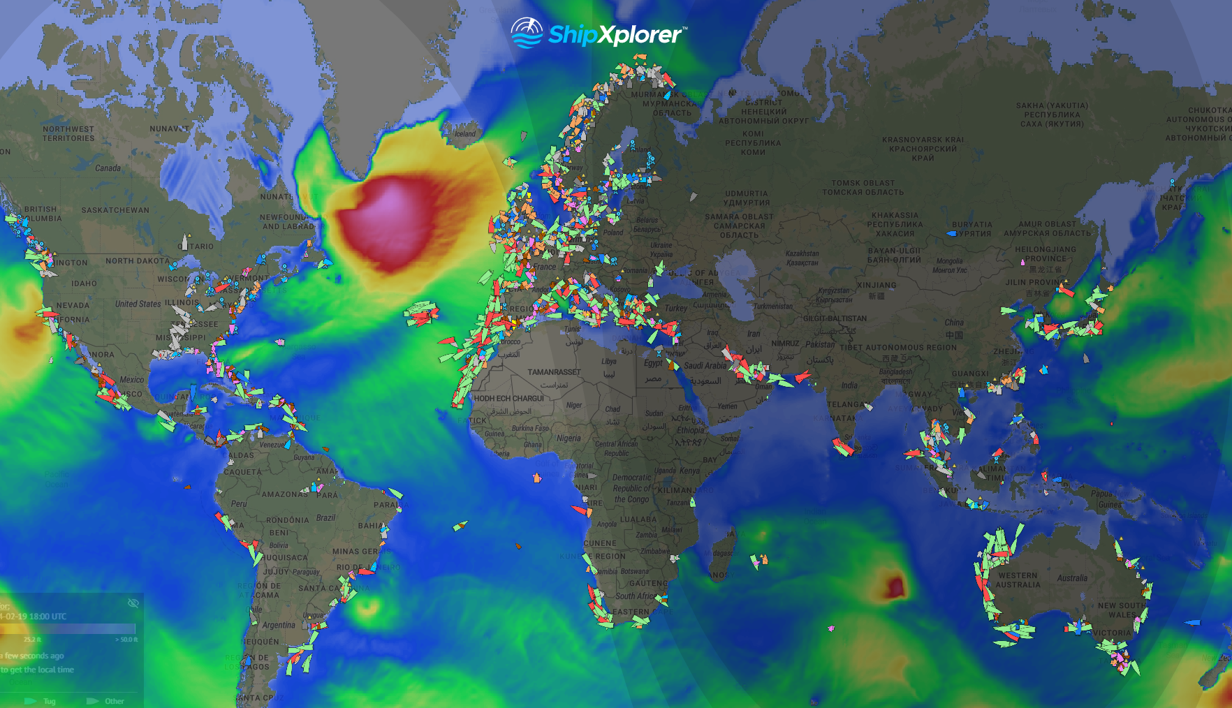
Wave Heights displayed on ShipXplorer.com
Smooth sailing is a mariner's dream, and ShipXplorer.com is making that dream a reality with its latest feature – Wave Height! Nautical enthusiasts and sailors, get ready to enhance your maritime experience by unlocking the power of wave data through ShipXplorer's user-friendly platform.
Discovering Wave Heights
Wave Heights displayed on ShipXplorer.com
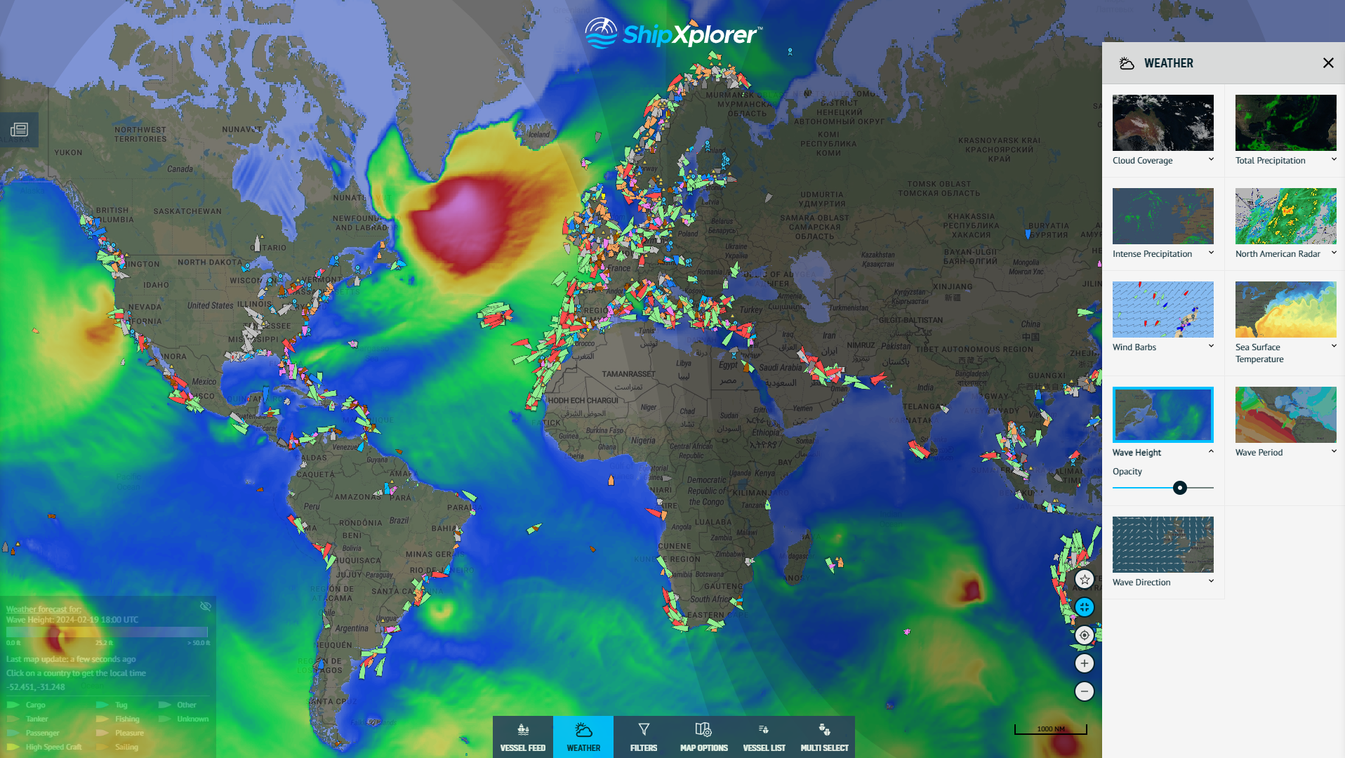
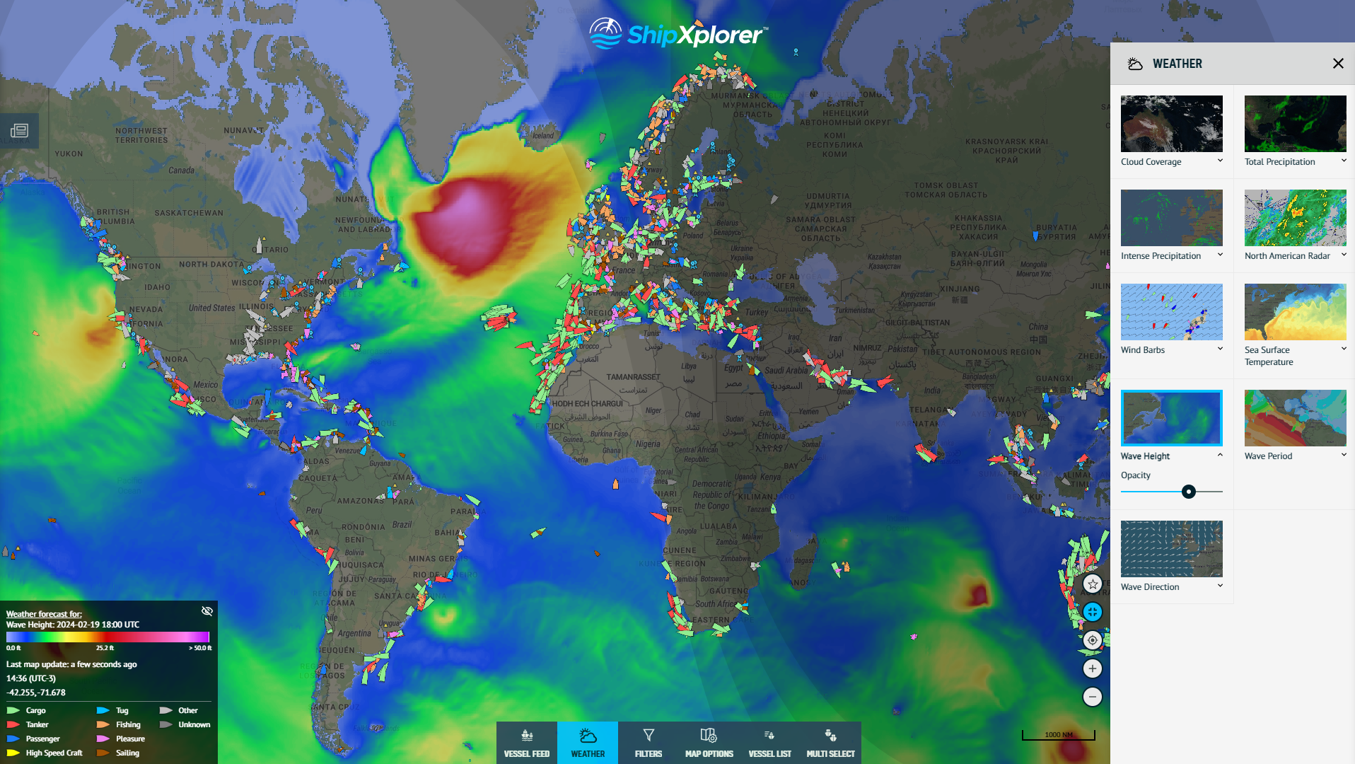
ShipXplorer.com has always been at the forefront of providing valuable information to seafarers, and the addition of Wave Height to its repertoire is a testament to their commitment. Accessing this crucial data is a breeze – navigate to the "Weather" section on the website's menu and click on "Wave Height."
Using the Wave Height Layer
Once you've accessed the Wave Height feature, a world of information awaits you. The interactive layer allows users to visualize the varying heights of waves across different regions. By clicking on the legend conveniently located on the left side of the website, you can decode the color spectrum representing wave heights.
Understanding the Legend
Wave Heights displayed on ShipXplorer.com
The legend serves as your key to comprehending the significance of each color on the map. As a general rule, the warmer the color, the higher the waves. Picture a gradient from cool blues to warm pinks – the shift from lower to higher wave heights is seamlessly represented.
More Pink, More Height
One glance at the legend, and you'll quickly grasp the correlation between color intensity and wave height. As the spectrum transitions into shades of pink, be prepared for a visual representation of higher waves. This intuitive color scheme simplifies the process of identifying regions with varying wave heights, ensuring a quick and efficient analysis for sailors and maritime enthusiasts alike.
Real-Time Wave Data
ShipXplorer.com is not just about static information; it provides real-time data to keep you informed about the dynamic nature of the seas. The Wave Height feature is updated regularly, allowing users to make well-informed decisions based on the latest conditions.
Benefits for Mariners
ShipXplorer's Wave Height feature proves to be invaluable for mariners in several ways. Whether you're planning a voyage, navigating through rough waters, or seeking optimal routes, having access to real-time wave height data enhances safety and efficiency. Stay ahead of the game by incorporating this tool into your pre-voyage preparations.
Subscribe now!
To use this feature and more, subscribe now at ShipXplorer.com/subscribe. Gain exclusive access to a plethora of tools and data designed to make your maritime journey safer and more enjoyable. Don't miss out on the opportunity to stay ahead of the waves and ships – subscribe to ShipXplorer.com today!
READ NEXT...
- ais-dispatcher
- ais-hub
- shipxplorer
- ship-tracking
- ais-data
- ais-coverage
- blog
2026-03-24 17:05 UTCHow to share AIS data to ShipXplorer with AIS Dispatcher!
Did you know? You can now share AIS data with ShipXplorer? Read our blog to learn more!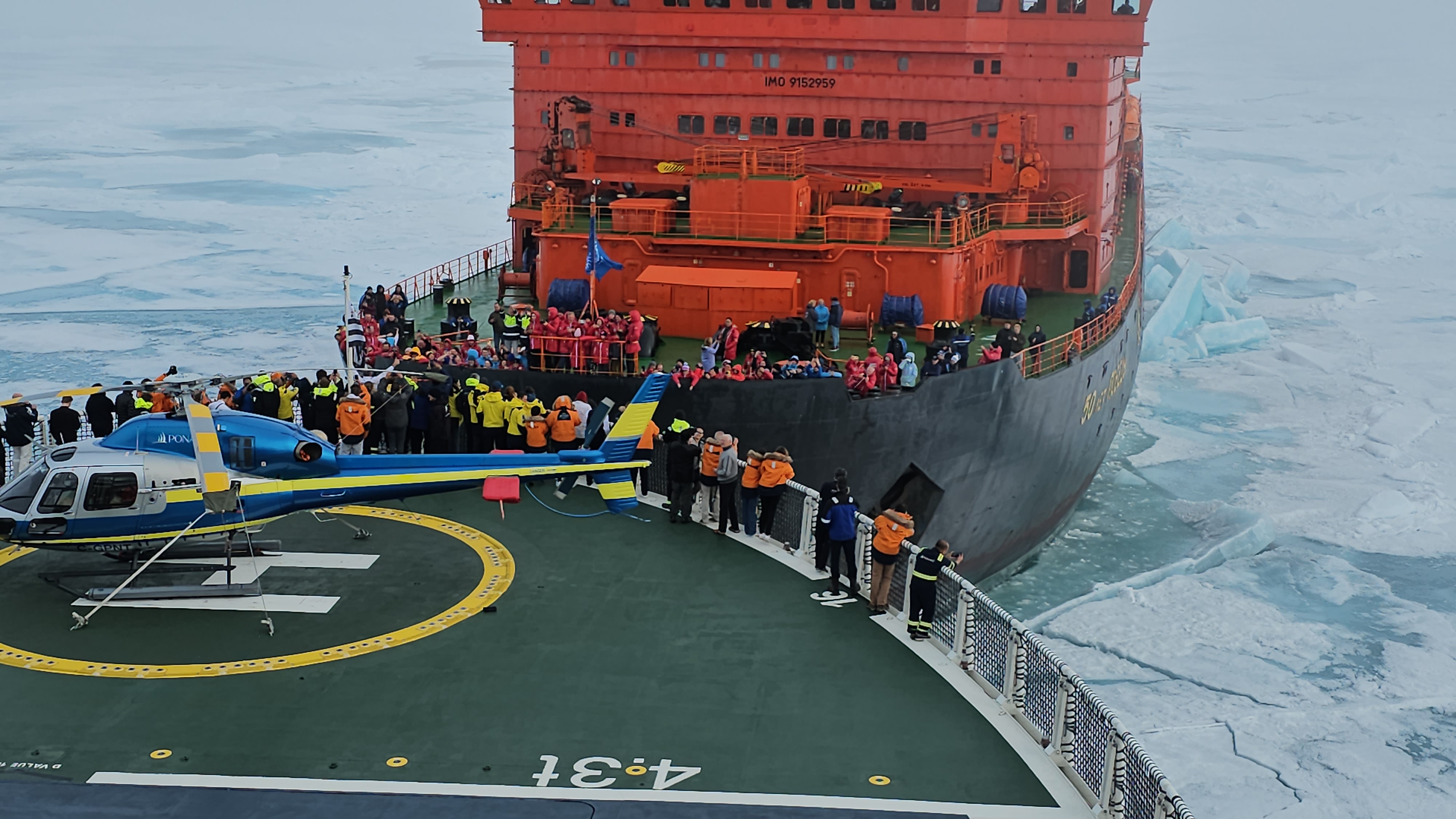
- arctic
- north-pole
- le-commandant-charcot
- north-pole-expedition
- 50-years-of-victory
- russia
- ukraine
- russian-ukrainian-war
- war
- peace
- ship
- blog
2023-07-21 16:37 UTCA Symbolic Encounter: Le Commandant Charcot and Russian Arktika-class nuclear-powered icebreaker 50 Years of Victory Extend a Message of Peace At the North Pole
Today, we have an extraordinary tale to share, one that unfolded amidst the awe-inspiring beauty of the Arctic. Against the backdrop of the Russia-Ukraine war, this encounter took on a profound meaning as the two ships exchanged waves of peace in the far reaches of the North Pole. Read about this symbolic moment on our blog!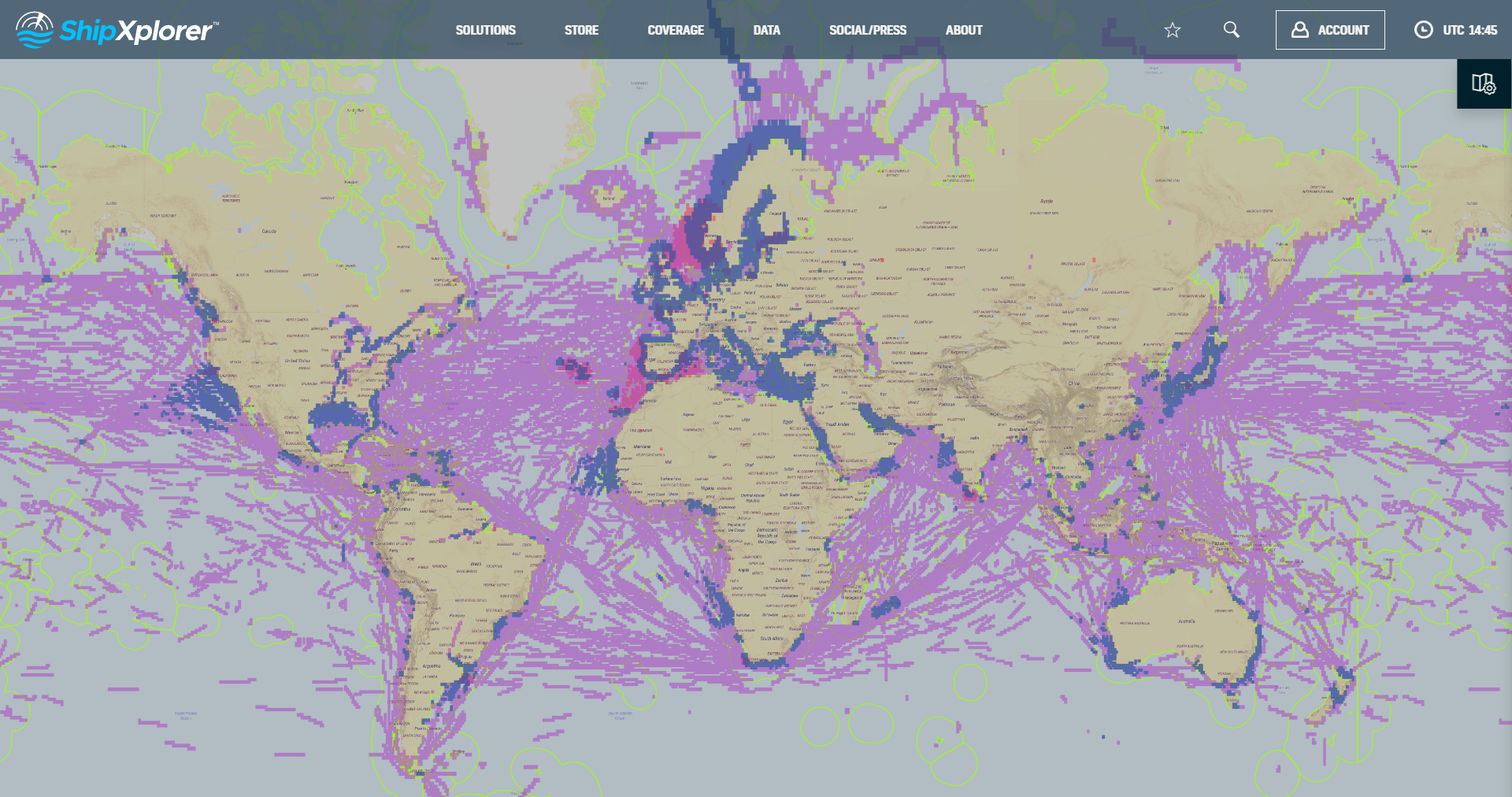
- shipxplorer
- ship-industry
- vessel-tracker
- ship-tracker
- ais
- hardware
- blog
2022-09-04 15:09 UTCSharing AIS data with ShipXplorer
Read our blog post and learn how to share AIS data and the benefits of being a ShipXplorer feeder.